Examples of ORNL DAAC OGC Services HTTP GET Requests
 WMS GetMap HTTP GET Request Example
WMS GetLegendGraphic HTTP GET Request Example
WCS GetCoverage HTTP GET Request Example
WMS GetMap HTTP GET Request Example
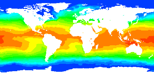
Fig. 1: Sea Surface Temperature in December, 1990
The above image was generated with the HTTP GET request below:
- https://webmap.ornl.gov/ogcbroker/wms?: URL of the ORNL DAAC WMS service
- SERVICE=WMS: this is a WMS request
- VERSION=1.1.1: indicate the format of this request is compatible with OGC WMS specification version 1.0.0
- REQUEST=GetMap: this is a GetMap request
- LAYERS=980_13: 980_13 (Sea Surface Temperature in December, 1990) is the requested layer. The list of available layers can be found in the ORNL DAAC WMS Capabilities document
- FORMAT=image/png: the generated map will be in PNG format
- STYLES=default: choose the default style to render the map
- TRANSPARENT=true: the generated map will be transparent in areas with nodata value
- SRS=EPSG:4326: the generated map will be in EPSG:4326 (WGS84) coordinate reference system
- BBOX=-180,-90,180,90: the bounding box of the requested map
- WIDTH=500: width (in pixels) of the requested map
- HEIGHT=250: height (in pixels) of the requested map
- TIME=1990-12: requested time step
- EXCEPTIONS=application/vnd.ogc.se_xml: if there is an exception from the ORNL WMS service, the error message will be in application/vnd.ogc.se_xml format
- originator=SDAT: this means the request was sent by the Spatial Data Access Tool (SDAT)

WMS GetLegendGraphic HTTP GET Request Example
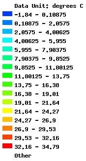
Fig. 2: Legend of Sea Surface Temperature in December, 1990
The above legend image was generated with the HTTP GET request below:
- https://webmap.ornl.gov/ogcbroker/wms?: URL of the ORNL DAAC WMS service
- SERVICE=WMS: this is a WMS request
- VERSION=1.1.1: indicate the format of this request is compatible with OGC WMS specification version 1.0.0
- REQUEST=GetLegendGraphic: this is a GetLegendGraphic request and the purpose is to get a legend image for a map
- LAYERS=980_13: 980_13 (Sea Surface Temperature in December, 1990) is the requested layer. The list of available layers can be found in the ORNL DAAC WMS Capabilities document
- FORMAT=image/gif: the generated legend image will be in GIF format
- TIME=1990-12: specify the time step
- originator=SDAT: this means the request was sent by the Spatial Data Access Tool (SDAT)
WCS GetCoverage HTTP GET Request Example
What are in the request:
- https://webmap.ornl.gov/ogcbroker/wcs?: URL of the ORNL DAAC WCS service
- SERVICE=WCS: this is a WCS request
- VERSION=1.0.0: indicate the format of this request is compatible with OGC WCS specification version 1.0.0
- REQUEST=GetCoverage: this is a GetCoverage request
- COVERAGE=980_13: 980_13 (Sea Surface Temperature in December, 1990) is the requested coverage. The list of available coverages can be found in the ORNL DAAC WCS Capabilities document.
- CRS=EPSG:4326: the downloaded data will be in EPSG:4326 (WGS84) coordinate reference system
- BBOX=-180,-90,180,90: the bounding box of the requested data
- RESX=1: spatial resolution of the requested data in X direction is 1 degree
- RESY=1: spatial resolution of the requested data in Y direction is 1 degree
- FORMAT=AAIGrid_FLOAT32: the downloaded data will be in Arc/Info ASCII Grid (FLOAT32) format
- TIME=1990-12: requested time step
- BANDS=1: subset the 1st band in the original data
- INTERPOLATION=NEAREST: use "nearest neighbor" interpolation method if resampling process is needed
- originator=SDAT: this means the request was sent by the Spatial Data Access Tool (SDAT)
